Understanding localization: how to define a local coordinate system by known points

What is localization?
One of the starting points of any survey is to choose a suitable local coordinate system for the area of your interest. In most cases, there are coordinate systems available that are optimized for that particular location. However, sometimes this doesn’t work. You simply don’t have the necessary coordinate system parameters, or they are not accurate enough. This is where localization comes in, the only requirement for this is the availability and applicability of benchmarks or known points.
Localization, also known as site calibration, is the process of comparing sets of known and measured point coordinates in GNSS software to calculate or adjust the local coordinate system parameters. Known points must have local coordinates in feet or meters, and measured points— global coordinates in degrees.

During the calculation process, the software applies a series of transformations, such as translation, rotation, scaling for horizontal adjustment, and an inclined plane for vertical adjustment. The app creates the best possible site reference frame, i.e. a coordinate system.
What data do you need to perform localization?
The localization process and its accuracy depend on the technical assignment and the data you have. You should carefully consider the availability of coordinate system parameters, the type of adjustment you want and can make, and most importantly, the number, distribution, and quality of control points.
Use of coordinate system parameters
The project can be created with or without coordinate system parameters: a projection, a vertical datum, and a datum transformation. If you have the parameters, but they aren’t accurate enough, it’s still better to use them. In general, you can try all the possible variations and compare the results.
Type of adjustment
The adjustment can be in plan or in elevation, or include both. It all depends on the known point coordinates—their availability and quality.
Number of points and their distribution
The number of known points has a direct effect on the resulting accuracy. In general, 5 to 10 is optimal. They should be evenly distributed over the survey area. The rule of thumb is to perform localization for smaller sites and collect measurements only within the area where the known points are located.

How does localization work in the Emlid Flow app?
Localization in Emlid Flow has a simple workflow with the all-in-one project option, so you don’t need to switch between projects. It also features a fine-tuned calculation algorithm. You can provide all the data you have, and the app will automatically select the best possible algorithm to calculate the coordinate system parameters.
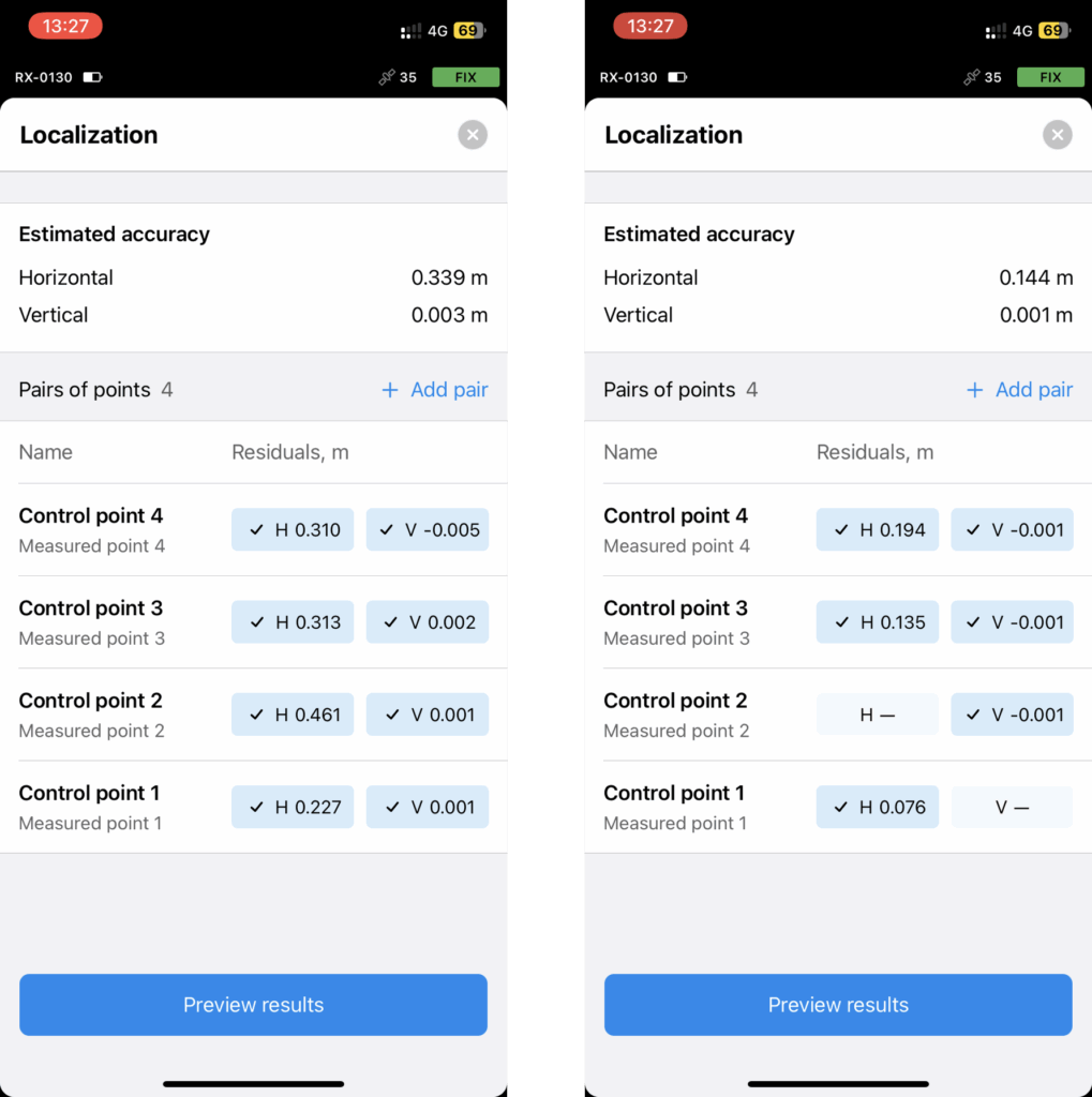
After adding pairs of known and measured points and a series of mathematical calculations, you get the residuals. These are horizontal and vertical “errors” for each pair of points that allow you to assess the accuracy of the resulting localization. In Emlid Flow, you can easily turn on and off horizontal and vertical point coordinates, or remove the ones that obviously stand out from the rest to achieve the desired accuracy. All these things can be done on a single screen, so you can watch the estimated accuracy changes in real time.
Get started with localization in the Emlid Flow app in a few steps:
- Open an existing project or create a new one. If you want to create a new project, specify the known coordinate system that needs to be adjusted or use the Global CS option.
- Tap Project localization.
- Add pairs of control and measured points.
- Analyze the residuals.
- Preview results and apply them to the project.
Learn more in our step-by-step guide.
Try localization with Emlid Flow
Localization is a perfect choice when you want to work in the local coordinate system, but you don’t have the parameters, or you need to adjust them to better fit the survey site. All you need are the control points at hand, Emlid Flow, and Reach. Survey using the usual workflow, and let the software calculate the parameters of the required local system for you. The new Localization feature is available with the Survey subscription in Emlid Flow. Try it now with a free 30-day trial.