Answering Your Questions About GNSS and Reach
You always have questions when starting something entirely new, especially when it’s about getting to know how GNSS works. Which type of accuracy do you need? Why doesn’t the height you’ve measured match the one in Google Maps? How do you set up Reach receivers at all, and do they even provide accurate data in your country? No wonder this seems way too confusing for a start. Don’t worry—we’ve got you covered! In this article, we’re answering some basic questions that should help you on your way of using Reach for a project. Got more to ask? Get in touch with us through our contact form or join the Community Forum—there’s tons of information from our users.
Contents
- Can I use the Reach RS+ rover with the Reach RS2 base?
- Do I need absolute or relative accuracy for my project?
- Will one receiver be enough for precise positioning?
- Will your receivers provide centimeter-level accuracy in my country?
- The height in my measurements is different from Google Maps. I’ve read it’s because of the ellipsoidal height. What does it mean?
- I do drone mapping and need to place GCPs. How to determine where exactly to place them on-site?
- Is it possible to use one base for several rovers?
- Does the base station have to be stationary or can it be stationed on a moving platform?
Can I use the Reach RS+ rover with the Reach RS2 base?
There’s no technical restriction on using a multi-band base and single-band rover. However, it doesn’t make any significant difference from using two Reach RS+ in terms of performance. Having Reach RS2 as a base set up with Reach RS+ as a rover will work as if both of your receivers were single-band.
If you want to have a multi-band solution, you need two multi-band receivers.
Do I need absolute or relative accuracy for my project?
It depends on your project goals and specifics. If you aim to simply measure the distance between several points, you’re good to go with the relative accuracy. Need to stick your measured points to global coordinates? In such a case, the absolute accuracy is what you’re looking for. Here’s how you can break it down by tasks:
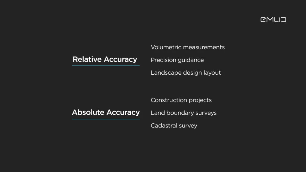
We have a guide on placing the base with the section about relative and absolute accuracy. Take a look at it if you would like to learn more about the difference between them.
Will one receiver be enough for precise positioning?
That’s yet another thing that depends on the type of your project—whether it requires accurate measurement in real-time (so you work in RTK mode) or you can process the results later (with PPP).
RTK/PPK always implies using a reference station. For centimeter precise positioning, you need a rover for collecting points, and a source of corrections. Now there are two options you can choose between: either to set up a rover with a static base or to have it receive corrections from an NTRIP service. In any case, for precise positioning, one rover alone is not enough. Learn about how RTK works in our docs.
One receiver can be used when you log raw data for PPP—the option you can go for with Reach RS2. Export and submit RINEX logs to a PPP service, and wait for it to send you the precise position of a measured point. Quite handy when you don’t have a base station or NTRIP available nearby. You can visit our docs section to learn more about how PPP works.
Will your receivers provide centimeter-level accuracy in my country?
Yes, for sure. The satellites cover the whole world. It makes no difference in which country you live, the receiver will accept the signals from satellites anyway. Your country might not have an NTRIP network but satellite signals are available in any part of the world. If you want to know more about how satellites help receivers to determine your position on Earth, watch our video about GNSS Positioning.
The height in my measurements is different from Google Maps. I’ve read it’s because of the ellipsoidal height. What does it mean?
First of all, remember that Google Maps are really very approximate, and the data there might be far from accurate.
Second, there are different heights used for measurements—geoid, orthometric, and ellipsoidal. Check out the pic and spot that they don’t quite match:
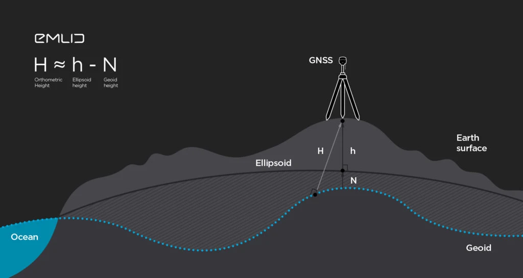
These heights may differ between each other by up to several meters. That’s why it’s important to check beforehand which type of height your project requires.
I do drone mapping and need to place GCPs. How to determine where exactly to place them on-site?
Ground Control Points (GCPs) are the reference points you put on the ground and survey before a drone mapping mission. These points are used to stitch the pictures the drone takes more accurately.
There are some general rules you can use when placing GCPs. First of all, it’s reasonable to distribute points evenly on the ground—you would want them in each corner and in the center of the surveyed site. If it’s safe, place GCPs on the highest and the lowest points, mark the elevations and changes of the landscape.
Here’s a video tutorial on how to place GCPs—check it out to get a better idea:
To learn more about the drone mapping and positioning GCPs, check out our article Breaking Down the Drone Mapping.
Is it possible to use one base for several rovers?
There’s no technical restriction for using multiple rovers with one base. You can connect as many rovers as you need.
However, the number of rover connections depends on how you transmit corrections. If you use LoRa, then there’s no limit. If you use NTRIP, then it depends on the provider’s terms of use. Some of them allow sending corrections only to one rover at a time.
Does the base station have to be stationary or can it be stationed on a moving platform?
Reach receivers need a stationary base to perform accurate measurements. Which doesn’t mean you can’t move a base around your survey site. Just make sure that the moment you do it, your rover doesn’t use it for corrections. Pause the rover’s data collection, move the base to another known point, and proceed with the RTK survey.