Evolution of mapping: from clay tablets to GNSS receivers
Throughout history humans have needed to understand their place in the world. Today, we rely on drone-created maps and GPS navigators for everyday tasks like finding the best route and perform high-precision jobs with sophisticated GNSS receivers. But it wasn’t that long ago when people didn’t have much more than a piece of paper with, frankly, quite approximate measurements.
History is a way to study whatever stands behind the things and technologies we’re used to. By diving into this article, you’ll explore the milestones that brought us from ancient clay tablets to today’s cutting-edge maps made with drones and GNSS receivers. Whether you’re a history lover, a technology enthusiast, or just curious about the story behind everyday tools, this article offers a blend of education and insight.
Table of Contents for the Article
- Ancient Maps
- The Map As a Statement
- Horoscopes That Created Maps
- Up and Down and Up Again: Renaissance Maps
- A Mistake Worth Making
- Triangulation and The New Era of Mapping
- Advancements in Surveying Equipment
- Mapping Becomes Institutional
- Struve Arc
- Pivotal Times
- Surveying Equipment Innovations
- Mapping Under Fire: How Surveying Tools Helped in World War I
- Space Helps Explore the Earth
- GNSS Receivers in Modern Mapping
Ancient maps
As soon as people understood that the world was bigger than their village and neighborhood, they realized the need to somehow solidify the picture of the world. This marked the beginning of mapping.
However, the first maps were quite far from having any accuracy. In fact, the main point of these maps was to state some sort of idea. As mapping technology progressed, people developed surveying equipment and surveying accessories that significantly improved the precision and utility of geographical representations.
The map as a statement
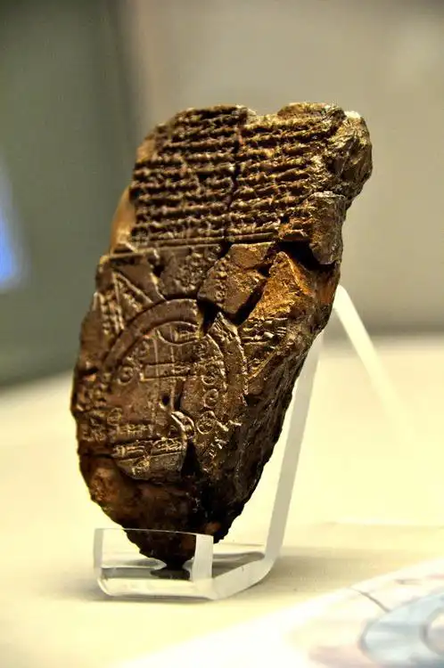
One of the first map-like examples was the Babylon clay tablet called The Map of The World, created between 700 and 500 B.C. It actually only had Babylon in the center, a river, and a couple of regions around it—not particularly suitable for any sort of navigation. However, despite the lack of practical use, it helped the map holder to begin exploring the world with himself in the center.
Romans went further in making a map a statement. One of the most famous Roman maps is a map of the whole Roman Empire called the Tabula Peutingeriana. It was a very narrow and very long map (0.34 meters high and 6.75 meters long) and it represented all the roads you could take from Rome. For its time, it was a progressive map, although still quite schematic. Besides the practical use for travelers to know which road to take, the Tabula Peutingeriana bore the idea of the unity of Romans. This was the way to document the size and internal boundaries of the Empire.
Horoscopes that created maps
Around the second century AD, the highest level of accuracy was the number of days you needed to get from one point to another on foot or by ship. There were people called bematists—specialists trained to measure the distance in their steps. Most of the distances were estimated based on this information plus the astronomical observation made with simple instruments like gnomon.
However, Ptolemy made a huge step towards creating the maps as we know them. Ptolemy was an astronomer, mathematician, and eventually a geographer from Roman Egypt. His idea was that if you know the place of birth of a certain person, his horoscope will be more precise. So he started gathering information from the travelers.
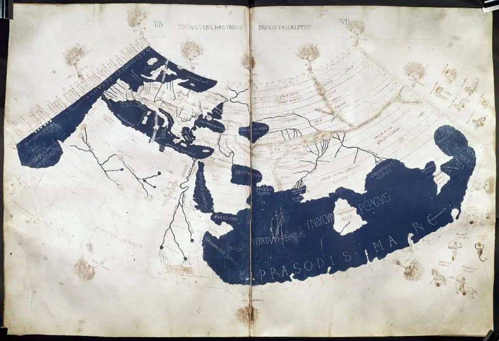
He improved the perspective projection to show the spherical Earth on a flat map. It was also Ptolemy who proposed precise methods to fix the geographical position of an object. Do you know the coordinate system, longitude, and latitude? Ptolemy’s idea.
Around 150 AD, he published his eight volumes of Geography. Basically, this scientific work became the prototype for a GIS. Those books contained maps, the longitudes, and latitudes of some objects, signs with legends, etc., paving the way for modern surveying equipment and software.
Up and down and up again: Renaissance maps
Ptolemy made a great breakthrough in mapping—too bad it was followed by Medieval times. During Medieval times mapping experienced little to no progress in terms of accurate representation.
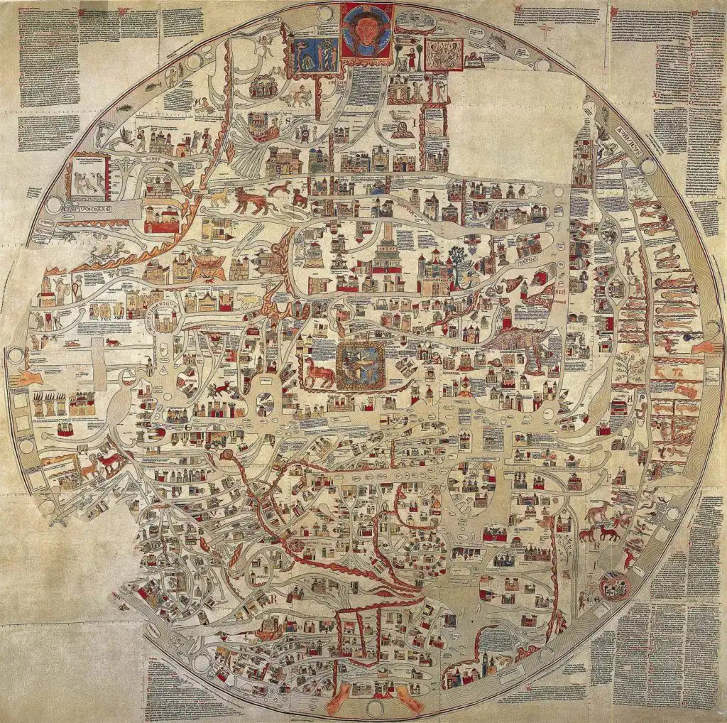
The Mappa Mundi, or the maps of the world, was closer to the Babylonian map than Ptolemy’s map. These circular maps were more of a symbol, and usually, the religious zeal would be stronger than the accuracy. Beautiful but useless for navigation.
However, with the Renaissance Age coming, mapping experienced new growth and faced new challenges and requirements.
A mistake worth making
The Age of Exploration required much more accurate maps. The ships were sailing the world, the trade was actively on—an accurate map meant safety and efficiency.
Christopher Columbus was using the maps influenced by the Roman period. In 1492, his crew ended up on the shores of America—thanks to Ptolemy and his miscalculations, who thought the world was much smaller and also used different measurements in his maps. This mistake opened two more huge continents to explore and map.
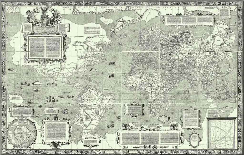
The beginning of the 16th century brought the first atlas created by Gerardus Mercator. He was also the one who came up with a mathematical projection, helping to represent the surface on a globe or map. We still use his representation in many ways.
Triangulation and the new era of mapping
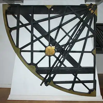
In 1620, Gunter’s chain was invented: a chain of 100 links 20.1 meters long. To build a route and measure the distance, the chain links were pinned to the ground till the endpoint. But the next big steps became possible because of totally new inventions. The telescope and the prototypes of theodolites, quadrants, and logarithm tables allowed exact triangulation to take its place in mapping.
As most surveyors know, triangulation is one of the main principles used in satellite positioning. Well, we wouldn’t be able to use it now if it wasn’t for Willebrord Snellius in 1615–17.
He wasn’t the one inventing the triangulation—that was first done centuries ago in Greece, then in China. However, he probably was the first who resurrected this knowledge from the Medieval dark ages and applied it to measure the circumference of the Earth.
Snellius used high spikes of the churches for his triangular calculations. He and his students performed 53 triangular measurements in 14 cities of the Netherlands. According to his calculations, the circumference of Earth was 38,653 km. He slightly miscalculated—the actual one is 40,075 km—but it is still a very impressive result that significantly pushed mapping forward, similar to the advancements brought about by modern surveying accessories and GNSS receivers.
Advancements in surveying equipment
During the 18th and 19th centuries, maps became symbols of power. With a proper map, wars could be won, land could be divided because the boundaries could be defined. So the maps took another step forward, this time to become more unified and detailed.
Also, the precision of these maps was slowly increasing. Around 1730, an English mathematician John Hadley, and an American glazier Thomas Godfrey discovered the sextant. It was a great deal for precise navigation because the sextant allowed the measurement of the angle between the horizon and astronomical objects. This technological advancement is analogous to modern surveying equipment, which provides crucial data for detailed and accurate mapping projects today.
Mapping becomes institutional
The maps were becoming more of an industry and less of a one-man art kind of a thing. Given that, the institutionalization of mapping and cartography was just a matter of time.
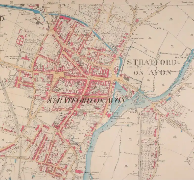
In 1791, Great Britain created The British Ordnance Survey – initially to map Scotland and use this information for military purposes. Later the same principles of mapping were applied to some areas of England, and the whole thing was named the Principal Triangulation of Britain.
By 1840, all of Wales and most of the English counties were covered with the one-inch triangular survey.
The United States Geological Survey was created back in 1879, first of all, to study the nation’s land. Besides the mapping, USGS also studied the natural resources of the country and worked on regulating land use.
Both of these agencies are still working today. They do more or less the same things they did before, however, they now, definitely, use more advanced surveying equipment to enhance their mapping capabilities.
Struve Arc
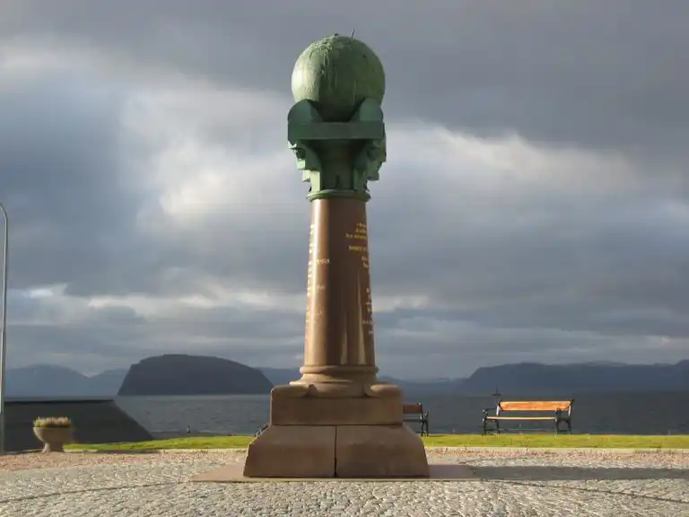
One of the remarkable stages in learning about how to understand the Earth was the creation of the Struve Geodetic Arc. Between 1816 and 1855, an astronomer Friedrich Georg Wilhelm Struve, carried a continuous triangular survey to measure a long segment of a meridian. A forty-year long survey—that’s what you call dedication!
Struve Arc is a chain of points marked with statues, obelisks, plates. This chain goes through 10 countries and is over 2,820 km long. The northern point is situated around the Norwegian town Hammerfest, and the southern point is located near the Black Sea in Ukraine.
The main idea of this survey was to establish the exact size of the planet and its shape. It became a significant part of the Earth study and the ability to determine yourself in the world.
Pivotal times
The 19th century made maps “popular”. It was the era of cartography when maps were becoming more and more common. Printing maps became much cheaper and easier—therefore, their mass consumption took place. It was not only a way to strategically plan a military operation. It also became a sign of economic growth, a way to navigate when traveling across the country.
In 1884, the Greenwich prime meridian became a universal starting point. The maps were going global, and there was no way to stop this. The 20th century brought a drastic change to the way maps were created, and that’s where we can actually start talking about mapping as we know it today, incorporating advanced GNSS receivers that further revolutionized the field.
Surveying equipment innovations
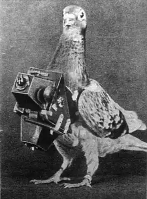
The 20th century was all about looking for something big: the new inventions, the new approaches, new challenges. Aerial photography was a predecessor of drone mapping. It started back in the middle of the 19th century and gained popularity in the 20th with the invention of the semi-automatic camera. The aerial maps, photo intelligence, even pigeons with the photo cameras on—cartography was desperately looking for a big breakthrough.
Mapping under fire: how surveying tools helped in World War I
By the early 20th century, the British Ordnance Survey was mostly famous for its leisure maps. However, with World War I entering the stage, the initial military purpose of this agency was resurrected. The older maps of France appeared to be inaccurate and useless for serious strategic purposes, so the group of surveyors urgently re-mapped a huge piece of the Western front line.
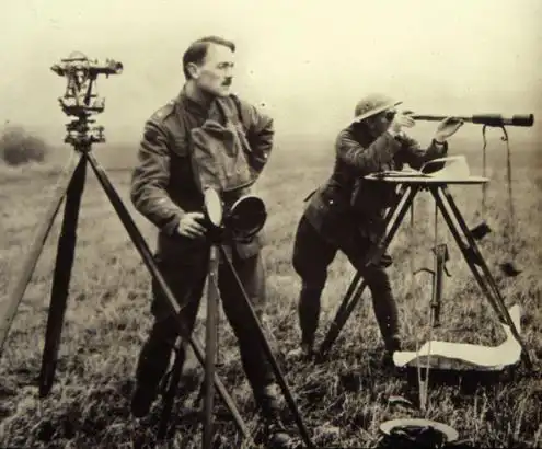
The British surveyors were mostly using theodolites in their on-site survey. Using the church towers and spikes as reference points, they were surveying the front line under the fire. Besides the natural problem of getting shot, they also faced the issue of the constant change of the environment. Their reference points could get destroyed by artillery and re-built slightly off the initial point, which led to miscalculations in the final maps.
At this point, aerial mapping became a significant advantage, two airplanes of British Ordnance were gathering intelligence data about the German trenches and positions.
Space helps explore the Earth
The aircraft photography used during World Wars proved the idea that mapping things from above is a workable idea. What’s higher than airplanes? Spaceships.
The satellite launch became the biggest breakthrough possible. The first satellite, “Sputnik,” was launched in 1957, then GPS satellites in 1978, then GLONASS in 1982. This became the start of satellite positioning and accurate detailed mapping of the Earth’s surface. To learn about the Earth, we had to go into space. Satellite constellations made global mapping possible for the first time in history.
Both GPS and GLONASS were first listed as military objects. Starting from the mid-1990s, with computers entering the houses of the man in the street, global satellite positioning became more universal and affordable.
If back in the 19th century, accurate maps were mostly under the authority of the army and government, now the entry threshold is much lower. A setup for drone mapping still requires some specific surveying equipment, but it is certainly not as complicated as renting a plane or an air balloon with specially trained personnel to map your crop fields.
GNSS receivers in modern mapping
Cartography was developing as an important instrument for overcoming the complexity of organized knowledge about the world we live in. Thanks to GNSS and a significant and constant improvement of the technologies, mapping became a less privileged industry.
GNSS receivers, such as Reach RS2+ and Reach RS3, are used for accurate drone mapping. Acting as a base for a drone, collecting the GCPs—Reach receivers provide users with the benefits of many centuries of mapping development. Learn more about the receivers and order one for your own surveying projects.
› Appendix
Image 1. Amin, O. S. M. Map of the World from Sippar, Mesopotamia [Photograph]. https://www.ancient.eu/image/2287/.
Image 2. Chierico, F. A. Ptolemy’s world map reconstructed from his “Geography” [Photograph]. https://commons.wikimedia.org/w/index.php?curid=1936973.
Image 3. The Ebstorf Map created circa 1235, By. [Photograph]. https://commons.wikimedia.org/w/index.php?curid=778427394.
Image 4. Alvesgaspar. (2006, April 23). Mercator’s map of the world by Gerardus Mercator [Photograph]. https://commons.wikimedia.org/w/index.php?curid=730484.
Image 5. Quadrant of Snellius. [Photograph]. https://www.wikiwand.com/en/Museum_Boerhaave.
Image 6. The Ordnance map of Stratford on Avon. [Photograph]. https://libguides.bodleian.ox.ac.uk/finding-maps/os.
Image 7. Bandarin, F. The monument of Struve Arc in Norway [Photograph]. https://whc.unesco.org/en/documents/113656.
Image 8. Pigeons were used to fly over the enemy’s line to capture photos for military intelligence. [Photograph]. https://warfarehistorynetwork.com/2019/03/15/warfares-unsung-pigeon/.
Image 9. Crown Copyright. Surveyors mapping the battlefield during WWI [Photograph]. https://history.blog.gov.uk/2014/05/13/mapping-for-war-and-peace/