
 BLOG
BLOG
What is PPK? Post-Processed Kinematic for remote surveying and drone mapping
PPK stands for Post-Processed Kinematic. It’s a GNSS positioning technique that delivers centimeter-level accuracy by processing raw satellite data offline, after field work is complete—instead of streaming corrections in real time like RTK (Real-Time Kinematic).
Here’s how it works in plain terms: both your base station and rover (often mounted on a drone, vehicle, or pole) record raw GNSS observables (satellite measurements) to a file during the survey.
You then process these files on your computer afterward, using software like Emlid Studio, to calculate precise positions. The payoff is the same centimeter accuracy as RTK, but without needing a radio link, cellular connection, or NTRIP caster in the field.
PPK vs RTK: how they differ
Both PPK and RTK use GNSS (Global Navigation Satellite System) receivers to achieve centimeter-level accuracy. The key difference is timing.
| Aspect | RTK (Real-Time Kinematic) | PPK (Post-Processed Kinematic) |
|---|---|---|
| When accuracy is calculated | During the survey, in real time | After the survey, on your computer |
| Corrections delivery | Streamed live via radio or cellular | Applied during post-processing |
| Field setup | Base station + rover + live link (radio, LTE, or NTRIP) | Base station + rover; no live connection needed |
| Baseline limit | Typically 10–40 km depending on setup | Up to 60–100 km in good conditions |
| Field feedback | Immediate (you know position accuracy in the field) | Results available after processing |
| Cost per job | Recurring fees (caster, data plan, radio) | None (use free software like Emlid Studio) |
| Backup option | You need a fallback if the link drops | PPK works as a backup to RTK if real-time fails |
The bottom line: RTK gives you answers in the field; PPK gives you flexibility and lower cost. Many teams use both—RTK when coverage is solid, PPK when it’s spotty or unavailable.
Why PPK belongs in your workflow
PPK is built for the jobs where maintaining a real-time connection is difficult, expensive, or impossible. Here are the real-world scenarios where it shines:
- Zero connectivity required: work anywhere with clear sky. No NTRIP caster, no cellular data plan, no radios to manage. You can fly a remote canyon, survey an island, map a mountain—the data is logged locally and processed later.
ㅤ - Greater distances: radio and cellular coverage drop off. With PPK, your baseline distance is limited only by atmospheric conditions and satellite geometry—not by your radio’s range.
ㅤ - Predictable costs: PPK has zero per-job costs once you own the receivers and free software (as Emlid Studio).
ㅤ - Resilience to dropouts: you can use PPK as a live backup to RTK. If your real-time corrections fail mid-flight, your receiver keeps logging raw data. Process it afterward and recover centimeter accuracy even though the live link broke.
ㅤ - Auditable results: your RINEX logs are a full record of every satellite observation. Reprocess them with different settings, updated satellite ephemerides, or improved reference data. Then, you can rebuild your solution anytime to meet changing accuracy demands or new standards.
ㅤ - Wide compatibility: RINEX is an industry standard. Combine rover logs with public reference networks (CORS, IGS), your own base stations, or third-party processing software. No vendor lock-in.
ㅤ - UAV timing precision: when a drone’s camera triggers, there’s always a tiny delay between the command and the actual photo. This is solved by recording camera time marks via hot shoe with microsecond precision. Each photo’s coordinates are computed from high-rate GNSS data, not interpolated.
ㅤ - Simpler field operations: start logging, fly or measure, and process at your desk. Less complexity in the field means less that can go wrong under time pressure.
How PPK works: the workflow
1. Field setup: base and rover logging
Both base and rover record raw GNSS logs independently. These are usually stored in RINEX format—the industry standard for satellite observations.
Requirements for reliable results:
- Clear sky and minimal interference: work in open areas. Avoid buildings, dense trees, power lines, radio transmitters, and high-current equipment. Multipath (signals bouncing off nearby surfaces) degrades accuracy.
ㅤ - Time overlap between base and rover: start logging on the base before the rover begins moving, and stop after it finishes. The entire survey session must overlap in time. You can trim logs later if needed.
ㅤ - Keep the baseline reasonable: modern receivers work out to ~60 km in PPK under good conditions. Accuracy drops with distance due to atmospheric decorrelation. Aim for less than 10–20 km when possible, and keep both receivers in similar environments.
ㅤ - Use consistent logging rates: base stations should log at 1 Hz minimum. Rovers should log at 5 Hz (vehicle or pole) or 10 Hz (UAV). These rates ensure enough data points to solve the fixed integer ambiguity.
ㅤ - Match satellite systems: configure both base and rover to use the same GNSS constellations (GPS, GLONASS, Galileo, BeiDou, etc.). Mismatched systems complicate processing.
ㅤ - Accurate antenna heights: enter receiver antenna heights correctly in your survey app. Reconfirm them during processing. A 10 cm error in antenna height propagates to your final positions.
ㅤ - Known base coordinates: determine your base station coordinates carefully—via surveyed mark, CORS reference, or previous RTK session. An incorrect base position biases all rover results.
2. Post-processing: from logs to coordinates
After field work, import your base and rover RINEX logs into post-processing software (Emlid Studio is free). The software:
- Aligns the logs in time.
- Trims data to overlap period if needed.
- Reviews data quality (satellite count, signal strength, multipath).
- Solves the double difference between base and rover.
- Resolves integer ambiguities for fixed solutions.
- Outputs precise coordinates for each rover epoch.
The result is either a continuous track (like a high-accuracy GPS trail) or discrete point coordinates. For drone surveys, the software also writes precise geotags into your images for use in photogrammetry software.
Real-world scenarios: when to use PPK
Continuous track of measurements
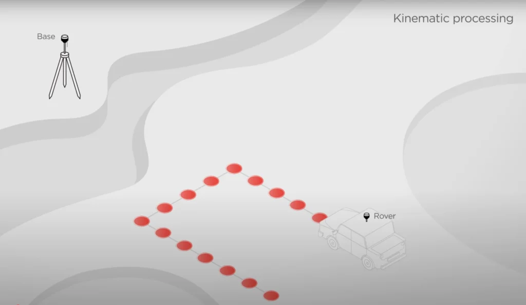
Mount a receiver on a car or survey vehicle to log a continuous GNSS track. Drive roads, utility corridors, or asset routes once. Process the data afterward to get CAD-ready linework—road centerlines, pipeline routes, fence lines, building footprints—all at centimeter accuracy, no RTK link required.
Real example: A municipal utilities team used a vehicle-mounted rover to map underground cable runs across a 40 km area. PPK eliminated the need for a base station or cellular link. They processed the data the next morning and had survey-grade linework ready for GIS.
UAV mapping and orthomosaics
PPK is ideal for large-area drone surveys—especially on remote or large sites where maintaining an RTK link is impractical.
The workflow:
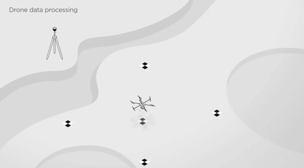
- Place a base station on known coordinates at the site.
- Fly your drone with a module or with onboard camera time marks
- Both base and drone log raw GNSS throughout the flight.
- Camera records event marks via hot shoe (or timestamp log) at each photo trigger.
- Post-process the base and rover logs in Emlid Studio.
- Output: precise geotags for every image.
Feed these georeferenced photos into Pix4D, Agisoft, DroneDeploy, or other photogrammetry software for centimeter-accurate orthomosaics. No ground control points needed—just a known base location.
Real example: an agricultural firm surveyed 800 hectares of farmland for irrigation planning. Instead of placing 100+ ground control points, they used a vehicle-mounted base and flew a PPK-ready drone. Processing took 2 hours; they had survey-grade orthomosaics the same day.
Note for RTK drone users: even if your drone supports RTK, logging PPK backup data is smart insurance. If the real-time link drops, your data is still usable—reprocess it and recover accuracy.
Note for DJI drone users without hot shoe: standard DJI Mavic and Phantom cameras don’t have hot shoe. Use ground control points (GCPs) instead—simple and effective for smaller areas.
Stop & Go surveying
Position your rover at specific locations (GCP marks, building corners, utility poles, cadastral points) and pause for 10–60 seconds to collect data. Move to the next point. Repeat across your survey area.
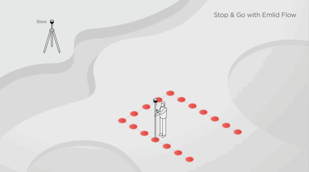
This workflow balances speed and accuracy. You capture discrete survey-grade points without logging a continuous track. Perfect for:
- Control network densification.
- Establishing construction stakes.
- Asset location and inventory (manholes, valve boxes, pole locations).
- Topographic detail shots.
- Corridor mapping with dense point spacing.
Setting up PPK with Reach receivers
Emlid’s Reach receiver family supports both RTK and PPK workflows. Here’s what each is designed for:
For pole/vehicle surveys:
- Reach RS4 Pro: professional flagship with all-band GNSS, IMU tilt compensation, and dual cameras for AR stakeout.
- Reach RS4: all-band RTK/PPK without cameras.
- Reach RS3: multi-band with tilt compensation and dual-band radio.
- Reach RS2+: entry-level professional; supports PPK baselines up to 100 km.
For drone mapping:
- Reach M2: compact 35g GNSS module; logs PPK data and syncs camera time marks via hot shoe.
All receivers log raw GNSS data in standard RINEX format. Configure logging in Emlid Flow (free mobile app) and post-process in Emlid Studio (free desktop software).
Processing PPK data in Emlid Studio
After collecting base and rover logs in the field:
- Export results: coordinates, geotags, or continuous track.
- Import both RINEX files into Emlid Studio.
- Trim logs to the overlapping time period (if needed).
- Review data quality: satellite count, signal strength, multipath indicators.
- Configure processing: select GNSS constellations, antenna type, reference frame.
- Run processing and review the solution (fixed ambiguities = best accuracy).
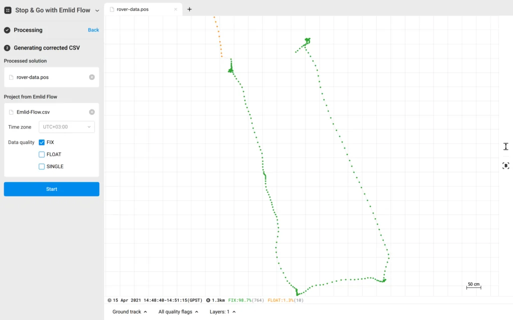
Emlid Studio is free and runs on Windows, macOS, and Linux. Processing is deterministic—you can reprocess with different settings anytime to optimize accuracy or audit your results.
Technical specs: accuracy and performance
PPK isn’t universal. Consider RTK if:
- You need immediate feedback in the field: RTK tells you if a point is good before you move. PPK answers come later.
- Your baseline is > 100 km: accuracy degrades significantly at very long distances.
- You work in dense multipath environments: urban canyons or forests where satellites are intermittently blocked. RTK’s higher positioning rate can overcome this; PPK’s offline logs might not.
- You need live corrections from a network: CORS networks or commercial NTRIP casters are available and cost-effective for your area.
Most teams use both: RTK when signal is solid, PPK when it’s spotty or unavailable.
Want to see PPK in action? Head over to our YouTube channel and watch the step-by-step tutorial on understanding PPK and getting the most out of your Reach receivers.
Frequently Asked Questions
Yes. Many receivers log PPK data in parallel with RTK. If the real-time link fails, process the PPK logs afterward and recover accuracy.
No. PPK uses only a base station on known coordinates. However, it’s good practice to place a few GCPs on site to check your results and validate accuracy.
Minutes to hours, depending on log length, receiver, and software. A 2-hour flight typically processes in 10–30 minutes on a modern desktop.
Yes. RINEX is standard format. You can reprocess with CORS or IGS reference data for improved accuracy or to meet specific reference frame standards.
Modern multi-band receivers like Reach RS2+, RS4, and M2 work reliably to ~60 km. Good conditions push this to 100 km. Beyond that, accuracy degrades due to atmospheric decorrelation.
Emlid Studio is free. Other free and commercial options exist (RTKLIB, Leica Infinity, etc.). RINEX is an open standard, so you’re not locked into one vendor.