Industry professionals share first-hand experiences with Reach RX high precision GPS rover
In 2022, Emlid launched the new Reach RX—a high precision GPS network RTK rover that eased the surveying in the field. Lightweight, compact, and easy to use—it’s all about the Reach RX. Let’s check how industry professionals leverage Reach RX in multiple surveying applications.
- Placing GCPs for drone mapping
- Construction project design
- Construction project inspection
- Explore Reach RX and get it for your work
- Additional resources
Placing GCPs for drone mapping
A popular Reach RX application is placing ground control points for drone surveys, which allows for collecting precise data across an area of interest.
Rory Gillies, an aerial mapping and GIS specialist from the UK, shared his experience collecting GCPs in a hillside area. Rory placed a Reach RS2+ base connected to the internet via a SIM card and passed corrections to Reach RX with the free Emlid NTRIP Caster. He performed several stakeouts and checked the locations in QGIS. The survey area was 60 hectares, and Rory found Reach RX to be an excellent option for land survey tasks in areas with proper cell coverage.
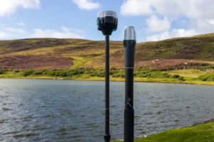
Rory Gillies placed GCPs with the Reach RS2+ base and Reach RX rover
Gabriel Couet, a geomatics technician and cartographer from Canada, took GCP preparation to the next level. He used Reach RX to prepare GCPs for georeferencing a local protected marsh, where he tracked seasonal changes in aquatic vegetation. He couldn’t step off the boardwalk into the marsh for practical and legal reasons. However, carrying the entire GNSS setup of Reach RX and the Emlid survey pole in a carrying bag slung over his shoulder made things easier.
After performing a drone flight and processing the data in Pix4D, the resulting orthomosaic maps were well-aligned and provided an insightful temporal comparison.
Construction project design
Michael Lambert, a virtual design and construction manager from Texas, conducted a topographic and planimetric survey for a Williamson County road to produce a 3.5-mile rehabilitation and extension design for construction. He used Reach RX to collect existing features such as flowlines and surface utilities in the construction area and placed GCPs for drone mapping. After that, he placed the Reach RS2+ base to stream corrections to a drone and performed a flight. To create a planimetric map, Michael processed the obtained results using the Carlson and SimActive software.
Having surveyed with Reach RX, Michael highlighted the ease of configuring Reach RX to receive corrections from an NTRIP service using an internet connection on a phone.
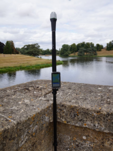
Similarly, Joe Lawson, who owns a surveying services company in the UK, used Reach RX, FARO scanner, and a total station to geolocate the wall in a river for a new eel pass design. He then processed the survey results in 3D modeling software. Joe recommended using Reach RX for topographic surveys that require some quick basic numbers in areas with available mobile internet. He also noted that Reach RX is a good fit when you can’t use a setup with a base.
Tore Berthelsen, a CAD operator in the construction industry from Norway, used Reach RX for stakeout while working on the building rotation project. His setup included Reach RS2 base streaming corrections to Reach RX via Emlid Caster. He was excited about the portability of Reach RX because it doesn’t require much space and can be used wherever decent LTE network coverage is available. Additionally, the receiver’s bright LED helps him remain visible in the dark.
Construction project inspection
Reach RX can be used to establish the location of man-made objects on-site.
Brent Wiebe, who performs topographical surveying and layouts for construction projects in Canada, used his Reach RX to inspect his latest project. Brent confirmed the location of screw piles for the foundation of a concrete building and marked out future roads and right-of-ways for the building and its utilities.
His setup combined Reach RX and Reach RS2 as base streaming corrections via Emlid Caster and provided uninterrupted service with perfect results. All data obtained were further processed in software programs like AutoCAD Civil 3D, QGIS, and Revit.
Brent admitted that he had only planned to test drive his Reach RX, but as soon as he began to use it, he knew he was hooked.
Our users have used Reach RX for a variety of projects and praised its compactness, portability, and ease of use. Many of them also highlighted its ability to receive corrections from an NTRIP service in an instant. Reach RX has proven to be a good fit for both drone mapping and construction projects in urban areas with good cell network coverage.
Explore Reach RX and get it for your work
When you’re looking for a precise and portable network rover for RTK surveys, Reach RX is the perfect solution. If you want to have your own base, we have the Network Base and Rover Kit for you. You can also combine Reach RX with the Reach RS3 base and pass corrections via our free Emlid Caster. This setup will work just like any NTRIP service but adds the benefit of your own forever-free way to stream RTK corrections using high-precision GPS technologies.
Reach RX and the Network Base and Rover Kit are available in the Emlid online store and ship worldwide from our warehouses. You can also buy them from official Emlid dealers—find your official Emlid dealer here.
Last but not least: To get your project featured, don’t forget to tag @Emlid in your posts on social media! We’re always glad to learn more about your work.
Additional resources
For more details on using Emlid GNSS / GPS receivers and land survey software, check out our blog articles. Explore how a reliable GNSS receiver can simplify your workflow and bring centimeter accuracy to your survey projects.