GNSS vs GPS: differences, accuracy, and real-world use cases
In the world of surveying and drone mapping, accuracy is everything—and that starts with understanding the technology that makes it possible. You’ve probably heard the terms GPS and GNSS tossed around, but while they’re often used interchangeably, they actually refer to different levels of satellite navigation systems.
In this article, we’ll dive into what GNSS is, how GPS fits into the picture, what is the difference between GNSS and GPS and why GNSS is a game changer for surveyors.
GNSS vs. GPS: practical comparison
People often use “GPS” to mean any satellite-based positioning, but technically GPS is only one part of GNSS. Here’s the simple definition:
- GNSS (Global Navigation Satellite System) is the umbrella term for satellite constellations that provide positioning, navigation, and timing (PNT) worldwide.
- GPS (Global Positioning System) is the U.S. satellite navigation system — and the most widely recognized name.
GPS was the first widely available satellite navigation system. Its long-standing use and integration into countless consumer devices over the years have made it a household name.
GNSS includes several satellite constellations maintained by different countries. There are four of them: GPS (USA), GLONASS (Russia), Galileo (EU), and BeiDou (China) with global coverage and as two regional systems QZSS (Japan) and IRNSS or NAVIC (India).
| GPS | Global Positioning System | United States | 31 satellites |
| GLONASS | Globalnaya Navigatsionnaya Sputnikovaya Sistema | Russia | 24 satellites |
| Galileo | Europe’s own global navigation satellite system | European Union | 23 satellites |
| BeiDou | BeiDou Navigation Satellite System | China | 44 satellites |
| QZSS | Quasi-Zenith Satellite System | Japan | 4 satellites |
| IRNSS | Indian Regional Navigation Satellite System | India | 7 satellites |
Most modern receivers, including smartphones, tablets, drones, vehicles, and professional surveying equipment, use multiple constellations at the same time. That means they’re doing GNSS positioning, even if the interface still says “GPS.”
GNSS vs. GPS: what changes in everyday use?
The biggest practical difference is this: GNSS gives your receiver more satellites to work with. More satellites usually means:
- More stable positioning (fewer dropouts);
- Faster fix time in difficult conditions;
- Better accuracy consistency, especially in non-ideal environments.
That matters a lot when signals are blocked, reflected, or weakened — for example in cities, forests, construction sites, near cliffs, or around buildings.
For simple everyday navigation, GPS is a perfectly fine label and a smartphone will usually get the job done. But as soon as you need more stable positioning in challenging environments (cities, forests, terrain), or higher accuracy for professional work, GNSS becomes the more correct choice.
Here are a few practical examples to help you choose quickly:
| Use case | Better technology | Best device | Why |
|---|---|---|---|
| Everyday navigation (Maps, car directions) | “GPS” (consumer term) | Smartphone / car navigation | Simple and familiar wording, accuracy is usually “good enough” |
| Cities, forests, tricky environments | GNSS | Multi-constellation phone / handheld | More satellites = fewer dropouts and more stable positioning |
| Fitness tracking (running/cycling) | GNSS | GNSS sports watch | Cleaner tracks, fewer jumps near buildings/trees |
| Mapping, surveying, machine control | GNSS + RTK | RTK base + rover | Centimeter-level accuracy for professional work |
| Drones, robotics, automation | GNSS (often RTK) | Multi-band GNSS / RTK receiver | Better reliability and repeatability in real time |
What lies behind every system in GNSS?
Whether you use GPS-only or multi-constellation GNSS, the positioning process works the same way behind the scenes. Every GNSS constellation relies on three segments: space, control, and user, and all three must work together to deliver accurate position and timing.

Understanding these building blocks helps explain why GNSS (multiple constellations) usually performs better than GPS alone, and what limits accuracy in real-world conditions.
- Space segment: consists of satellites orbiting 20,000 to 37,000 kilometers above Earth, constantly broadcasting signals about their geographical position and time;
- Satellites: determine their position through constant communication with ground control stations, which track their location, monitor their orbits, and update the satellites’ onboard systems with the correct positional information;
- User segment: includes devices that receive GNSS signals and calculate positions using special algorithms.
Combining signals from multiple satellite systems effectively addresses the need for more reliable positioning. This provides broader global coverage and reduces blind spots.
How accurate are GNSS technology constellations?
The accuracy of different GNSS constellations varies based on several factors, including the quality of the receiver, the environment, and whether correction techniques (such as RTK) are used. However, each constellation has its inherent capabilities and accuracy ranges:
| System | Accuracy | Details |
|---|---|---|
| GPS | • Standard GPS: 3-5 meters • With DGPS: 0.5-1 meter • With RTK: Centimeter-level accuracy | GPS is the oldest and most widely used system, offering reliable positioning worldwide. Civilian-grade receivers typically experience meter-level accuracy, but with correction techniques, accuracy can reach centimeters. |
| GLONASS | • Standard GLONASS: 3-7 meters • With DGPS: 1-2 meters • With RTK: Centimeter-level accuracy | GLONASS generally provides slightly less accuracy than GPS in standalone use but is often used in combination with GPS to improve overall accuracy. GLONASS also has a slightly different orbital setup, which can be advantageous in high latitudes (closer to the poles). |
| Galileo | • Standard Galileo: 1 meter • High-Accuracy Service (HAS): Less than 20 centimeters • With RTK: Centimeter-level accuracy | Galileo is a newer system with advanced signal technology, providing higher accuracy than GPS and GLONASS in standalone mode. With the free Galileo High Accuracy Service (HAS), it offers location data with sub-meter accuracy. |
| BeiDou | • Standard BeiDou: 2.5-5 meters • With SBAS (Satellite-Based Augmentation System): 1 meter • With RTK: Centimeter-level accuracy | BeiDou is particularly accurate in the Asia-Pacific region, where its regional coverage is optimized. In global applications, BeiDou provides similar accuracy to GPS and Galileo. With SBAS, it can offer a meter-level accuracy. |
| QZSS | • Standard QZSS: 1-3 meters • With SBAS: Sub-meter to centimeter-level accuracy | QZSS, also known as Michibiki, primarily enhances GPS accuracy in the Asia-Pacific region, especially Japan. It works in tandem with GPS to improve performance in urban canyons and areas with poor satellite visibility |
| IRNSS | • Standard IRNSS: 5-20 meters • With SBAS: Sub-meter to meter-level accuracy with SBAS • With RTK: Centimeter-level accuracy | IRNSS, also known as NavIC (Navigation with Indian Constellation), provides accurate positioning services primarily over India and surrounding regions. Used with augmentation, it offers sub-meter to meter-level accuracy. |
The accuracy of different GNSS constellations
Why GNSS accuracy isn’t always perfect (and how it can be improved)?
For many everyday tasks like navigation, meters are enough. But for applications like surveying, mapping, machine control, and precision agriculture, meter-level accuracy isn’t sufficient, and that’s where correction techniques come in.
But even though GNSS can deliver reliable global coverage, typical consumer positioning is still often meter-level. That’s because real-world errors add up, including:
- Atmospheric delays (ionosphere and troposphere);
- Multipath (signal reflections from buildings, ground, metal structures);
- Poor satellite geometry (satellites clustered in one part of the sky);
- Clock/orbit inaccuracies (small timing and orbit errors).
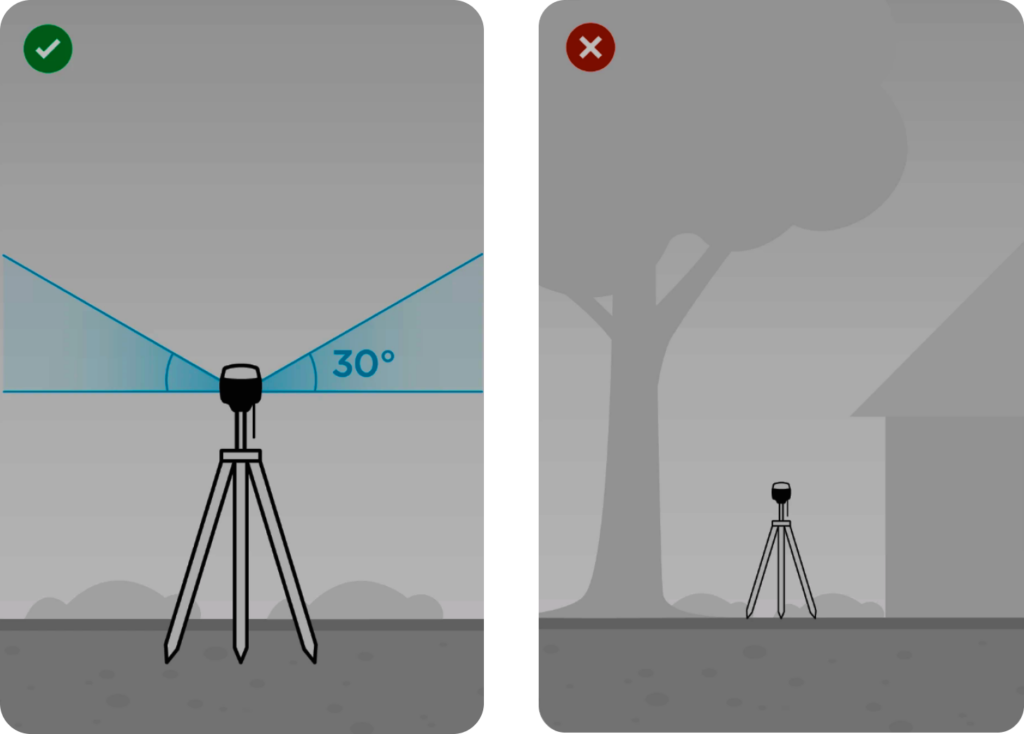
To minimize these issues and ensure optimal accuracy, it’s best to place GNSS receivers in open areas with an unobstructed sky view above 30 degrees, free from potential obstacles that could block or reflect signals.
DGPS: better accuracy for everyday positioning
DGPS (Differential GPS) is a correction technique that improves GNSS positioning using ground-based reference stations. These stations are installed at known coordinates, so they can calculate how much the GNSS position is “off” and broadcast correction data to nearby receivers.
As a result, DGPS can improve positioning from roughly 5–10 meters to about 1–3 meters, depending on conditions.
Note that DGPS is not the same thing as GPS (the U.S. constellation). It’s a method that can improve GPS and GNSS positioning.
Other satellite systems also have their own augmentation approaches, but the practical takeaway is the same: DGPS-level corrections help reduce error, but they still don’t reach survey-grade precision.
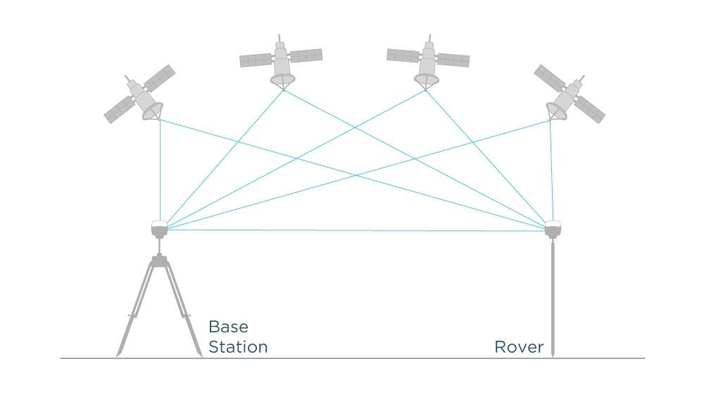
RTK: centimeter-level GNSS for surveying, mapping, and robotics
In the case of surveying and mapping, where centimeter accuracy is crucial, Real-Time Kinematic (RTK) technology comes to help. RTK is a technique that helps us to calculate the coordinates with centimeter-level accuracy in real-time.
The technique involves using one stationary reference receiver called a base station, and one moving receiver called a rover. The base receives data from satellites and transmits them, together with its own position, to the rover.
Using these data and receiving satellite positioning signals too, the rover calculates its position with centimeter-level accuracy and reliability.
Reach GNSS receivers for accurate surveying
If you are looking for surveying equipment, consider Reach RS4. This is an easy-to-use RTK GNSS receiver with centimeter precision.
If you need to collect data in hard-to-reach places at greater angles or need a connection to a third-party base, Reach RS4 is tailored for this. It comes with the handy Emlid Flow mobile app and the Emlid Flow 360 web application.
Frequently asked questions
Not exactly. GPS is one GNSS constellation operated by the United States. GNSS is the umbrella term that includes GPS plus other satellite systems like Galileo, GLONASS, and BeiDou, which many modern receivers use together.
GPS refers specifically to the U.S. satellite navigation system. GNSS refers to satellite navigation as a whole, including multiple constellations. In practice, GNSS often provides better reliability and positioning stability, especially in difficult environments like cities and forests.
GNSS is often more consistent than GPS-only because it can use more satellites at the same time. More satellites typically improve availability and geometry, reducing dropouts. Raw accuracy depends on conditions, but GNSS usually performs better in real-world scenarios.
Most modern smartphones use GNSS, meaning they can combine signals from GPS plus other constellations like Galileo and BeiDou. Even if your phone menu says “GPS,” it often still uses multiple satellite systems in the background for better performance.
Urban areas cause signal blocking and multipath, where signals reflect off buildings and arrive delayed. This confuses the receiver and reduces accuracy. Multi-constellation GNSS helps by giving the receiver more satellite options and improving positioning stability.
- RTK corrections explained: from base station to NTRIP service
- Introducing Emlid Reach RX: pocket-sized RTK GNSS receiver
- Basics of RTK GPS and GNSS for non-surveyors
- Accuracy and precision explained: surveying with high precision GPS
- Precise drone mapping with Emlid gear setup: GNSS base station, GCPs, and more
- Performing centimeter-accurate GPS / GNSS survey in RTK: video tutorial
- Answering Your Questions About GNSS and Reach
- Evolution of mapping: from clay tablets to GNSS receivers