
 BLOG
BLOG
The ultimate guide to setting up a GNSS base for centimeter accuracy
A correctly set-up base station is essential for accurate GNSS surveys in RTK. Since your rover’s coordinates are only as accurate as the base’s placement, any shift in the base will directly affect the rover’s measurements.
If you’re deploying an RTK GPS system for surveying, construction, or drone mapping, your RTK base is the anchor all measurements depend on. In this article and related videos, we’ll walk you through the key steps for setting up a base and explore methods to ensure reliable absolute centimeter accuracy in your projects.
We’ll also answer common questions like how an RTK base station works and how to set up an RTK base station in the field.
What is an RTK base station?
An RTK base station—also called a GNSS base station or GPS base—is a fixed receiver that sends correction data to one or more rovers in the field. This correction data allows the RTK GPS system to calculate positions with centimeter-level precision.
There are several types of base stations: permanent GNSS reference stations (CORS) and local base stations owned by users. In most workflows, setting up your own RTK base offers more flexibility and accuracy needed for professional surveying, drone mapping, and construction.
Before you set up a base, check if you need one. If your project falls within Emlid Corrections coverage (the US, the UK, most of continental Europe, Australia, or New Zealand), you can skip base setup entirely and get centimeter accuracy directly through Emlid Flow.
Check the coverage map for your site, then read on if a local base is still the right call for your project — for fully off-grid sites or permanent installations, it usually is.
Step 1: Coordinate system setup
To set up a base station for accurate data collection, each survey project requires selecting an appropriate coordinate system (CS). This choice ultimately depends on the coordinate system your base’s coordinates are in.
There are many CS options to choose from even within a single country, so selecting the right one is crucial for ensuring accurate results. In most cases, the required coordinate system and its parameters are specified in the technical assignment or official project documentation. If not, you can use public resources like the EPSG registry to find the appropriate system for your region.
When setting up a coordinate system for your project in the Emlid Flow app, you should configure the following settings using the obtained parameters:
- Coordinate system including the horizontal datum and its projection.
- The vertical datum providing an ellipsoidal height or a specific geoid.

In Emlid Flow, you can double-check your setup after configuring the coordinate system in the project. A notification will appear indicating the required horizontal datum for the base—make sure this datum is also specified in your technical assignment, official project documentation, or the EPSG registry.
Correct CS configuration ensures your GNSS base station broadcasts corrections aligned to the same datum used by your deliverables.
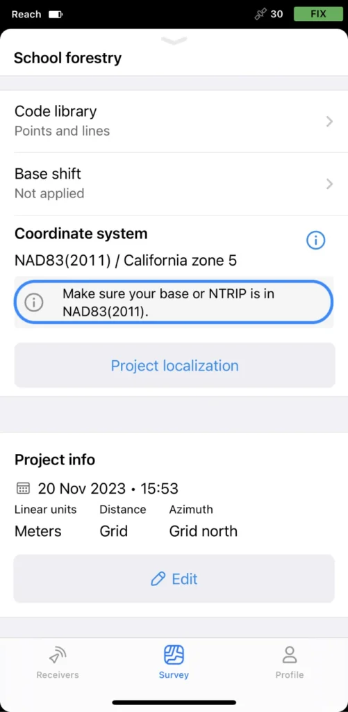
Check out our blog post to learn more about coordinate systems, their components, and setup.
You can also refer to our documentation on the coordinate system setup in Emlid Flow & Emlid Flow 360. This step is foundational before you install an RTK base station separately from your rover workflow.
Step 2: Choosing proper positioning
Once you’ve set up your coordinate system, you must determine proper base positioning. What does it mean?
In RTK, the base serves as the reference point for the rover. This means that even though measured with centimeter precision, the rover’s coordinates are only as accurate as the base placement.
Any shift in the absolute base position, defined in the particular coordinate system, will also affect the rover measurements. Thus, when setting up your base’s position, you can consider two ways of positioning:
Relative
If your goal is to understand how measured objects relate to one another—such as calculating distances between them without needing their exact positions, it’s sufficient to have relative positioning. In this case, you can average your base’s position and get a meter-level accuracy.
Since this approach works in standalone mode, each time you average the base position from the same location, the resulting coordinates may vary by several meters from both the previous values and the true position.
As a result, while relative accuracy between points remains consistent, absolute accuracy will be limited.
In Emlid Flow, this method is available as Average SINGLE. However, it’s important to note that in most professional surveying applications—especially those requiring precise georeferencing—this method is not commonly used.
Use relative mode only when you do not need absolute positioning from your RTK GPS base station and when you won’t integrate data with other sources.
Absolute
To achieve centimeter-accurate results that are not only consistent relative to the rover but also correctly placed within a specific coordinate system, you need to use absolute positioning. This means the base must be set to known, accurate coordinates.
By entering the true position of your base station, you effectively “pin” your RTK setup to the correct location on the ground. This ensures that all measurements taken by the rover are georeferenced precisely within the selected coordinate system, delivering absolute centimeter accuracy.
In simple terms, this is how RTK base stations work—they compare satellite measurements at a fixed, known point and transmit corrections to the rover in real time.
In Emlid Flow, you have two ways to set the base position accurately:
- Enter the coordinates manually: you need to have the base’s coordinates at hand or you should obtain the base coordinates using one of the post-processing methods.
- Use Average FIX method: this calculates an accurate base position using real-time corrections from an NTRIP service, provided you have an internet connection in the field.
Both methods ensure your data aligns with other geospatial datasets, making them ideal for professional surveying, construction layout, GIS mapping, and any task requiring high-precision positioning. Take a look at how using a known point compares to an averaged point for your base setup:

If you want to explore base setup theory in more detail, check out our documentation on base setup methods. In the meantime, let’s go over the available base setup workflows.
Step 3: Setting up base coordinates using Emlid Flow
As we established earlier, specifying known coordinates for your base location is the only way to achieve reliable centimeter-accurate absolute positioning in your survey.
Depending on the available reference data and field conditions, there are several ways to set up a GNSS base station over a known point. Here are the key base setup methods you can do with Emlid Flow and a Reach receiver, accompanied by videos to walk you through the setup process.
Setting up the base over a known point
If a known point is available, the best practice is to place your base directly over it and manually enter its coordinates. This method ensures the highest absolute accuracy since it ties your project to a predefined coordinate system.
In Emlid Flow, you can enter the coordinates of a known point or permanent survey mark or import them from an existing project using the point picker tool. This is the fastest way to set up an RTK base station with guaranteed alignment to your project’s datum.
In cases where the known point is obstructed or unusable, the base shift method allows you to adjust the base’s coordinates. You can position the base nearby and apply a linear shift based on a measured point using the Emlid Flow app.
This is helpful when you must install an RTK base station separately from the control mark due to obstacles or safety constraints.
Alternatively, you can check out the step-by-step guide on setting up your base over a known point in Docs.
Pro tip: record and store the antenna height, mount type, and mark ID in your project notes for repeatable RTK station setups.
Using average FIX for base coordinates
If no known point is available but you have internet access in the field, you can use real-time corrections from an NTRIP service to average your base’s position in FIX. This approach treats your base like a rover, allowing it to receive NTRIP corrections and gather data for a short period to establish accurate base coordinates.
Average FIX is a practical way to set up an RTK base station on a new site without existing control while still maintaining centimeter-level absolute accuracy.
If needed, you can learn more in the Averaging base position in FIX guide of our documentation. Make sure your RTK GPS module or receiver maintains a sustained FIX (e.g., 10–20 minutes) before committing the averaged coordinates.
Getting base coordinates using static data
In remote areas with no known points or internet access, Static processing is a reliable way to set up your base—if there’s a nearby CORS station. Log raw data on your base, download CORS logs, and post-process them in the free Emlid Studio software. After processing, enter the accurate coordinates in Emlid Flow.
This method is also used when establishing a semi-permanent GNSS base station or rooftop RTK base for long-term projects.
Store your processed coordinates as the official reference for your RTK GPS base station and reuse them for future surveys. You can also find a step-by-step guide in the Emlid Studio documentation.
Obtaining base position using online post-processing services
Ensure centimeter-accurate setup within the selected coordinate system using the Reach base and Emlid Flow. Whether you’re conducting RTK surveys on the ground or flying drones for aerial mapping, with this combo, you can manage your base station directly from the field and trust your data from the first point to the final deliverable.
If local CORS data isn’t available, PPP services like OPUS, AUSPOS, IBGE, or NRCan CSRS-PPP can provide precise coordinates for your GNSS base station based on static logs.
Find more details on using online post-processing services like AUSPOS, OPUS, IBGE, NRCan CSRS-PPP in the Emlid documentation. Once you receive final coordinates, update your base position in Emlid Flow and lock them in to prevent accidental changes to your RTK station setup.
Selecting the right base setup method depends on your project’s accuracy requirements and available resources in the field. By following these best practices and using the appropriate technique, you can ensure consistent, centimeter-accurate GNSS data in every survey.
For detailed instructions on configuring your base, visit our Base setup documentation. Pin this page for your team as the standard operating procedure for how to set up an RTK base station on any project.
Discover how Reach base and Emlid Flow streamline your surveying workflows
Ensure centimeter-accurate setup within the selected coordinate system using the Reach RS3 and Reach RS4 base and the Emlid Flow app. Whether you’re conducting RTK surveys on the ground or flying drones for aerial mapping, with this combo, you can manage your base station directly from the field and trust your data from the first point to the final deliverable.
Together, they form a reliable RTK GPS system you can deploy anywhere—fast to set up, easy to repeat, and simple for teams to adopt.
FAQ: Quick answers about RTK base stations
How does an RTK base station work?
The base observes the same satellites as the rover, compares measured ranges at its known position to expected ranges, and sends corrections via radio or NTRIP. The rover applies these to resolve ambiguities and output centimeter-level positions—this is the core of every RTK GPS system.
How to make or build an RTK base station?
Use a survey-grade receiver, a stable antenna mount, power, and connectivity (radio or NTRIP). Install the base at a secure, permanent location. Establish the base’s coordinates using a known point, averaging FIX, static processing, or PPP services. Document the setup for repeatability. Set up corrections output over the internet (NTRIP), radio, or TCP.
How do base stations work with drones?
First, a base station ensures your GCPs, checkpoints, and layout points land in the right place in your map. Second, an RTK base station sends corrections to an RTK drone to provide centimeter-accurate imagery in real time. Accurate base coordinates mean your drone lines up with other datasets—critical for construction, utilities, and asset management.