Customer story: scaling earthworks and utility projects with GNSS for construction
With 30 to 60 active construction projects running simultaneously, KLS Earthworks & Environmental’s surveying team struggled to keep up with the growing demand for layout and grade verification across job sites, while moving field decisions efficiently.
To solve this challenge, the company introduced Emlid RX and RX2 RTK GNSS rovers. The technology allowed supervisors to perform many layout and grade checking tasks themselves, without waiting for a surveyor to arrive on site.
The result was a major operational shift: fewer delays, more productive crews, and a surveying team that could finally focus on planning and long-term project support rather than constant emergency site visits.
- Scaling field support across more active sites
- Responsive field workflows with no delays
- The limitation of workarounds: why lasers weren’t enough
- Empowering the field with RTK GNSS
- From dependency to autonomy: field operations reimagined
- The new standard: how Emlid GNSS improved construction workflows
- Key takeaways
- Frequently asked questions
Scaling field support across more active sites
KLS Earthworks & Environmental provides earthworks, underground utility installations, and environmental construction services across Calgary and Saskatoon in Western Canada. To support these projects, the company operates a fleet of excavators, dozers, trucks, and other heavy equipment across numerous sites at the same time. As the company expanded, it saw an opportunity to modernize how layout and grade verification were delivered across that growing footprint.
Every construction project depends on accurate layout before work begins. Crews need reliable information about where to excavate, where utilities should be installed, and how deep the ground should be cut or filled. Traditionally, these tasks are performed by professional surveyors who establish control points, verify grades, and mark locations on site.
At KLS, these responsibilities fell to Survey Manager Daniel Kenny and his two colleagues. Together, the three-person surveying team supported approximately 20 supervisors working across dozens of projects.
With 30 to 60 active sites in motion, the team began refining its workflow so routine field checks could happen closer to the work itself, while surveyors focused on project setup, coordination, and oversight.
Responsive field workflows with no delays
Before KLS introduced GNSS to supervisors, Daniel Kenny and his survey team handled most layout and grade verification requests across multiple job sites. Supervisors would call when they needed support, and the survey team would decide where to go first.
Daniel would then evaluate which sites required immediate attention and travel between them throughout the day. Some days required multiple site visits in different parts of the city. As he describes it: “It felt like I was running around putting out fires.”
Sites where heavy equipment was waiting typically received priority. For example, a job site with two underground crews waiting for trench layout would be handled before another location that only required an elevation check.
This approach worked, but as the number of active projects grew, it became clear that some routine field checks could be done directly by supervisors with the right tools.
KLS did not want to replace surveyors. Instead, the goal was to make everyday layout and grade checks easier to handle in the field, while the survey team focused on planning, setup, and other specialized tasks.
The limitation of workarounds: why lasers weren’t enough
When surveyors could not reach a job site in time, supervisors sometimes used simpler methods to keep work moving. One of the most common approaches involved checking elevations using a rotating laser level tied to a known benchmark.
While this technique could provide basic elevation guidance, it had several limitations. Laser levels are useful for checking grade differences locally, but they do not provide precise coordinates or full layout capabilities.
Without proper surveying equipment, supervisors could not verify the exact position of utilities or excavation boundaries. That meant they could complete some checks independently, but more precise layout and verification still depended on survey support.
These methods helped cover part of the job, but KLS needed a more complete and scalable field workflow—one that supervisors could use confidently for routine construction checks while staying tied to project control and design information.
Empowering the field with RTK GNSS
To solve the problem, Daniel Kenny began exploring more accessible positioning technologies that could support field crews directly. He proposed introducing Emlid’s Reach RX and RX2 RTK GNSS rovers as part of the company’s surveying workflow.
RTK GNSS receivers use satellite positioning combined with correction data to provide centimeter-level accuracy in real time. This makes them suitable for tasks such as construction layout, grade checking, and as-built documentation.
The key advantage for KLS was usability. Unlike traditional survey equipment, the Emlid receivers are designed with intuitive software and simple workflows.
This made them suitable not only for surveyors but also for supervisors who needed to perform occasional layout tasks. Instead of requiring advanced surveying knowledge, supervisors could learn the basic workflow quickly and begin using the devices directly in the field.
Related reading: GNSS workflows for any construction team that cut your costs
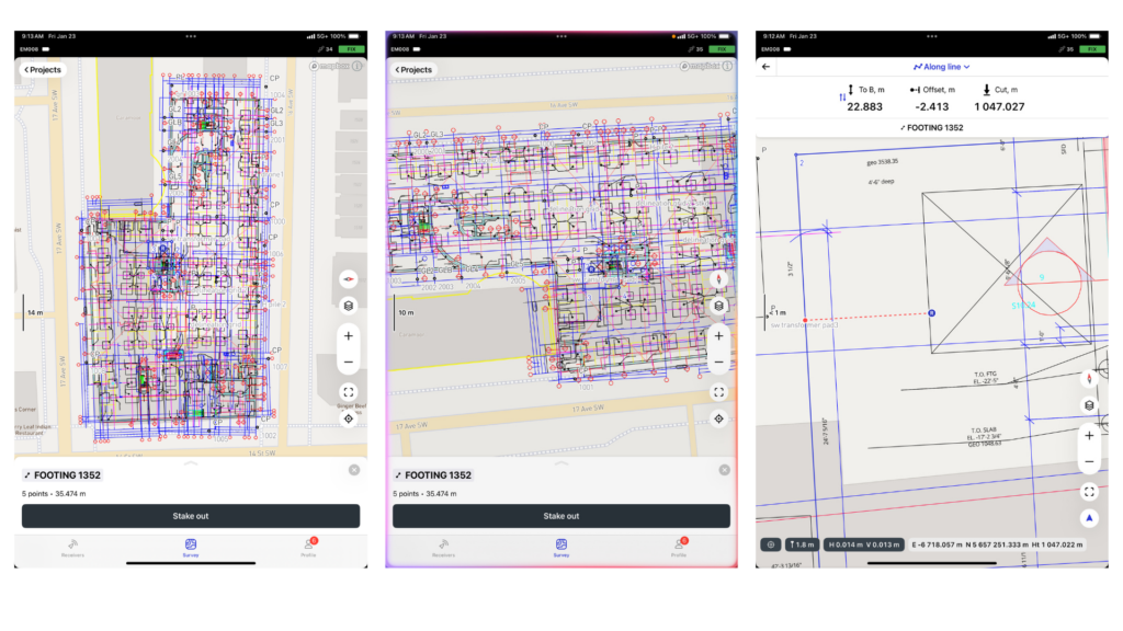
The transition happened faster than expected. Supervisors who previously avoided GPS technology began using the devices regularly. With the help of the Emlid Flow app, they could view project data, verify positions, and confirm grades while standing directly on the construction site. This allowed crews to continue working without waiting for survey support. KLS was seeing an increase in productivity after rollout.
From dependency to autonomy: field operations reimagined
Today, 20 supervisors across KLS projects use Emlid RTK GNSS rovers as part of their daily workflow. The devices are used for tasks such as grade verification, layout, and documenting completed work.
To maintain consistency across projects, the survey team established a clear workflow for using RTK GPS in earthworks operations:
- Connect to site control points provided by the general contractor.
- Perform layout and verify positions on site.
- Use Emlid Flow to match tagged ground points with design data.
- Conduct construction grade checking before excavation begins.
- Capture as-built measurements after the work is completed.
This structured process ensures that all measurements remain aligned with the project’s coordinate system and design drawings.
Emlid’s RTK GNSS also helps the team maintain accurate records of completed work, which is particularly important for large projects that involve multiple contractors and inspectors.
“In the past, our supervisors struggled to use survey-grade equipment and relied heavily on specialized surveying knowledge. After introducing them to Emlid’s RTK GNSS rovers, they quickly learned how to use high-precision positioning technology, and even started enjoying it.”
Daniel Kenny, Survey Manager, KLS Earthworks
Related reading: Minimize construction site visits: how to support your field crew remotely
The underground advantage: precision before the backfill
One of the areas where GNSS technology has been particularly valuable for KLS is underground construction. Installing utilities such as waterlines, storm drains, or sewer pipes requires precise trench layout and alignment before the pipes are buried. Once the installation is complete, access to these utilities becomes limited, making accurate documentation critical.
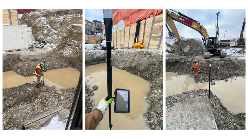
Using Emlid Reach RX and RX2 receivers, supervisors can verify trench positions and pipe alignment directly in the field. They can also capture as-built data to record the final location of utilities before the trench is filled.
This improves both construction accuracy and long-term documentation. For projects where utilities are installed and buried quickly, having reliable positioning data ensures that the exact location of underground infrastructure is recorded correctly.
Field proof: faster verification where the work happens
A real-world example highlighted the impact of this new workflow. During an underground construction project, a supervisor used an Emlid rover to confirm trench layout before pipe installation.
While he initially lacked experience with underground offset calculations, he quickly learned how to operate the GNSS receiver itself.
Standing directly inside the trench, he verified the layout and ensured the pipe alignment matched the design specifications. The crew was able to continue working without waiting for a surveyor to arrive on site.
Maintaining this level of productivity demonstrated how GNSS technology could support field crews directly. After seeing the benefits, KLS expanded its fleet of Emlid RX and ERX2 rovers to additional projects.
Urban challenges: high-stakes grading at the Sentinel Project
Another project where KLS successfully used Emlid’s receivers was the Sentinel development in downtown Calgary. The project involved building a five-story structure with a deep basement excavation.
Before foundation work could begin, crews installed piling around the perimeter of the site to create a shoring wall.
Footings were then excavated and filled with concrete to support the structure above. The site presented additional challenges because it sits on an old riverbed. Soil conditions were unstable, which made careful excavation and piling installation essential for maintaining structural stability.
During this project, the field teams used Reach RX receivers in multiple workflows:
- Confirming excavation depths.
- Verifying grades during foundation preparation.
- Maintaining alignment during piling installation.
Accurate positioning was especially important because the project was located in a dense urban environment where available working space was limited.
The new standard: how Emlid GNSS improved construction workflows
Since introducing Emlid RX and RX2 RTK GNSS rovers, KLS Earthworks has evolved from a more centralized support model to a more distributed field workflow. Supervisors can now carry out grade checks and layout-related tasks independently, giving crews faster access to the information they need and helping work progress more smoothly across active sites.
The technology also helped close the gap between specialized surveying tasks and day-to-day construction operations. Tasks that once required a professional surveyor can now be performed directly by field supervisors using intuitive positioning tools.
For Daniel Kenny and his surveying team, the benefits have been equally important. With fewer emergency site visits required, they now have more time to focus on:
- Project planning.
- Budgeting and cost analysis.
- Improving survey workflows across projects.
Instead of reacting to urgent layout requests throughout the day, the team can now take a more proactive approach to supporting construction operations.
“Emlid’s RTK GNSS technology changed how we operate at KLS Earthworks & Environmental. Projects are no longer delayed because supervisors can now confidently confirm grades and perform underground layout themselves. My surveying team can focus on more strategic work instead of rushing between sites to verify layout.”
Daniel Kenny, Survey Manager, KLS Earthworks
Key takeaways
Emlid Reach RX2 rovers help construction teams scale operations and improve productivity across multiple job sites. The field teams can now perform layout and verify positions on site, match tagged ground points with design data, run grade checking before excavation begins, and capture as-built measurements after the work is completed.
Looking for a scalable solution for earthworks and underground construction projects?
Try the Emlid RX and RX2 RTK GNSS rovers for construction layout, GIS data collection, utility mapping, and survey workflows—without the complexity of traditional survey equipment.
Frequently asked questions
GNSS for construction refers to the use of satellite positioning systems (GPS and other global constellations) to perform layout, grade checking, and as-built documentation directly on a jobsite. It enables accurate real-time positioning and reduces dependence on manual measurements.
RTK GPS uses Real-Time Kinematic corrections to achieve centimeter-level positioning accuracy. This allows contractors and supervisors to perform precise layout and earthworks surveying without waiting for a dedicated survey crew.
A GNSS receiver is a field device that receives satellite signals and correction data to determine precise coordinates. When combined with RTK technology, it becomes a powerful tool for construction layout, grade verification, and as-built documentation.
GPS supports underground construction by enabling accurate trench layout, pipe alignment, and utility placement before installation and burial. Crews can confirm offsets and elevations in real time, reducing errors and costly rework.