
 BLOG
BLOG
Earthworks planning and progress tracking: staying on grade, on schedule and on budget
Earthworks projects have a way of going wrong quietly. The design said move 5,000 m³. The site needed 7,000 m³. Nobody caught it until the invoice arrived.
That’s not a one-off. Inaccurate volume calculations, poor progress visibility, and late-stage QC failures are routine on sites that rely on traditional methods. The good news is that most of these problems are preventable—if your planning and tracking workflows are set up correctly from the start.
This guide breaks down what earthworks planning and progress tracking actually involve, where things typically go wrong, and how to run both more efficiently.
What earthworks planning involves
Earthworks planning happens before a single machine touches the ground. Done right, it gives you three things: an accurate picture of existing conditions, a validated digital design, and a clear baseline for measuring progress.
Existing terrain survey
This is the starting point of any grade control workflow. Before you can compare the existing ground with the design, you need an accurate model of the site as it is today.
Survey the site and collect enough points to create a reliable Digital Terrain Model (DTM). The required point density depends on the terrain: flat areas require fewer points, while sloped or irregular terrain requires more. Make sure your survey covers the entire project area and includes any features that affect grading, drainage, or earthwork calculations. The accuracy of the surface directly affects all subsequent cut/fill and staking results.
You can create a terrain surface in several ways:
- GNSS survey: Collect spot elevations with a Reach receiver and generate a DTM from the measured points.
- Total station or level: Survey elevations on a grid or along terrain breaklines.
- LiDAR: Capture dense point clouds using a ground-based or drone-mounted LiDAR system.
- Drone photogrammetry: Process aerial imagery to generate a terrain surface.
GNSS surveying with Reach is the fastest way to capture accurate site data. For projects that require a 3D model, Reach RX2 integrates with the PIX4Dcatch app on LiDAR-enabled iPhones, enabling both surveyors and non-surveyors to create centimeter-accurate models. The resulting surface can be processed in PIX4Dcloud or PIX4Dmatic and imported directly into Emlid Flow.
Cut/fill volume calculations
Once you have an accurate DTM, you can compare it with the design surface to calculate cut-and-fill volumes. This tells you how much material needs to be excavated, how much needs to be added, and whether the two balance on site or require importing/exporting material.
Miscalculated volumes at this stage are expensive. A 20–30% volume underestimate doesn’t just affect cost—it can affect project timeline, machinery requirements, and disposal logistics.
What progress tracking involves
Once earthworks are underway, tracking progress means answering one question consistently: is the ground matching the design? The answer needs to come in real time, so work can continue without waiting for routine survey verification. With a Reach receiver and Emlid Flow, any trained crew member can perform routine grade checks directly in the field, allowing issues to be identified and corrected without waiting for a dedicated survey.
Grade verification
Grade checks confirm that cut-and-fill operations are meeting the target elevations throughout the excavation and compaction phases. Rather than waiting for a surveyor to verify the grade before continuing, the excavator operator or another crew member can perform the check themselves using a Reach receiver and Emlid Flow. By comparing the current position with the design surface, they can view cut/fill values in real time and make adjustments immediately.
This way, the practical fix is to put the design surface into a field app, connect it to a GNSS receiver, and let operators and foremen check grades themselves as they work.
Related reading: A field guide to grade control using Reach receivers and Emlid Flow
Interim QA surveys
Quality assurance doesn’t have to wait until the project is complete. Throughout construction, crews can check the elevations to verify that they match the design before the next stage of work begins.
With a Reach receiver and Emlid Flow, any trained crew member can record object positions directly in the field. These intermediate QA checks help identify deviations early, reduce the risk of costly rework, and provide a documented record of the work completed at each stage. The collected data can also support client inspections, progress reporting, and contractor payment.
Related reading: QA/QC workflows in construction: a practical guide for your field crew
Progress volumes
Earthmoving progress is measured in cubic meters, not just in days on the schedule. Throughout the project, the site is periodically surveyed to capture its current state. Comparing the latest terrain surface with the original survey shows how much material has been excavated or placed. Comparing it with the design surface shows how much work remains before the finished grade is reached.
These volume calculations provide an objective measure of progress. They help project teams verify completed work, update production quantities, plan upcoming activities, and identify delays before they affect the construction schedule.
As-built documentation
As-built surveys provide an accurate record of the site as it was constructed. While a final as-built survey is typically delivered at project completion, capturing as-built data throughout construction gives teams much better visibility into ongoing work.
Using a Reach receiver and Emlid Flow, crews can periodically survey completed areas and synchronize the data to Emlid Flow 360. The project team can compare each as-built with the design surface, verify that work meets specifications, and identify any discrepancies while they are still easy to correct. By the end of the project, the final as-built is already largely complete, with a documented history of construction progress rather than a single survey collected after all work has finished.
Related reading: As-built surveys: a field-to-office workflow with Emlid Reach receivers
Emlid solutions for earthwork projects
Most problems in earthworks come from outdated information or delayed verification:
- An incomplete terrain survey leads to inaccurate volume calculations.
- Working without a digital design surface makes it difficult to consistently verify grades.
- Waiting until the end of the project to collect data leaves little opportunity to correct mistakes before they become expensive.
When routine grade checks depend on a surveyor’s availability, construction work can slow down unnecessarily.
Using a Reach receiver together with the Emlid Flow & Emlid Flow 360 ecosystem helps avoid these issues by making surveying and verification part of the daily workflow.
Crews can collect terrain data, compare the current ground with the design surface, verify grades, and record completed work directly in the field. The collected data is immediately available to the project team through Emlid Flow 360, ensuring everyone works from the same up-to-date information and can make decisions based on the site’s current state.
Together, Reach, Emlid Flow, and Emlid Flow 360 help keep fieldwork connected to the latest project data and reduce common sources of error:
- Working without a design surface in the field. When crews rely on paper drawings or visual estimates, grade verification depends on experience and guesswork. Loading the design surface into Emlid Flow makes checks faster and more consistent.
- Collecting data only at the end. A final as-built shows what happened after the work is complete. Periodic quality checks show what is happening while there is still time to correct deviations.
- Waiting for surveyors to perform routine checks. Survey professionals remain essential for control, boundaries, and high-risk measurements. But routine grade checks and progress shots can be done directly in the field, reducing delays during active earthmoving.
- Working from disconnected data. When the site team, project manager, and client use different versions of the same data, visibility breaks down. Keeping project data synchronized through Emlid Flow 360 helps everyone work from the latest information.
Typical workflow
The complete workflow can be broken down into the following stages and steps:
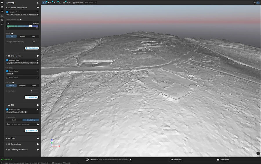
Creating a surface
Survey the existing terrain by collecting all objects on the site to prepare the design surface, then export it in LandXML format. As mentioned earlier, you can take advantage of the Reach RX2 and PIX4D scanning kit to create the terrain surface.
Preparing a project
In the office, sign in to Emlid Flow 360 with your Emlid account and set up the project:
- Create a new project in your workspace.
- Select the required coordinate system from the coordinate system library or import the localization parameters.
- Create and apply a code library with attributes, if needed.
- Import geometries in CSV, SHP, KML, or DXF format, if needed.
- Add map layers, if needed.
- Import the design surface.
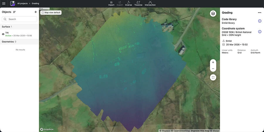
Now you can invite field engineers to the workspace so they can access the project and start working with the surface.
Tips for running earthworks planning and tracking efficiently
The following best practices show how to organize these activities and how Reach, Emlid Flow, and Emlid Flow 360 can help streamline each stage of the process.
- Survey the existing terrain before finalizing the design.
Don’t rely on historical topographic data or the design team’s assumptions about the site. Collect fresh terrain data before the design surface is locked. Discrepancies found at this stage cost time for revision. Discrepancies found during construction cost money.
- Use consistent control points throughout the project.
Tie every survey—terrain, as-built, grade check—to the same control network. Mixing coordinate systems or re-establishing control mid-project introduces errors that are difficult to trace and expensive to resolve.
- Upload the design surface to a field app before work starts. Your crews need to know what they’re digging toward. Load the DTM or design surface into your field software—Emlid Flow supports this directly—so operators and supervisors can check grade in real time without waiting for a surveyor to arrive.
- Set a schedule for QC checks. Decide in advance how often you’ll capture data. For large earthmoving operations, weekly or bi-weekly as-builts are typical. Stick to the schedule. Each as-built is your opportunity to recalculate progress volumes and catch deviations before they require rework.
- Give supervisors the tools to do routine checks themselves. Grade verification, cut/fill checks, and simple staking don’t require a licensed surveyor. Reach receivers combined with Emlid Flow make centimeter-accurate grade checking accessible to supervisors and foremen without deep surveying expertise. KLS Earthworks scaled to 60 simultaneous active sites by doing exactly this: supervisors handled routine layout and grade checks, freeing the survey team to focus on tasks that actually required their expertise.
- Connect field data to the office in real time.
Your project manager shouldn’t have to wait for the field team to manually transfer survey data before tracking progress. By synchronizing projects between Emlid Flow and Emlid Flow 360, field-collected data becomes immediately available in the office. This gives project managers access to the latest site information, helping them identify issues early, monitor progress, and keep clients informed without delays.
- Calculate progress volumes from the same surface you used for the original estimate. When tracking progress, always compare current as-built data to the same original terrain survey used for your initial volume calculation. Introducing a different base surface mid-project makes your progress numbers meaningless.
Bonus: Ground improvement
Earthworks don’t always end with moving material. On many projects, the existing soil must be densified or reinforced before construction begins—an alternative to deep piling that transfers loads to bedrock and is often a faster and cheaper option. Contractors like Menard specialize in these ground improvement techniques, staking out treatment locations, verifying installation points, and recording as-built positions for quality control.
With Reach receivers and Emlid Flow, field crews can handle all the tasks using the same equipment and setup, positioning treatment points to centimeter-level accuracy and documenting completed work for project records.
The underlying principle of a well done earthworks project
Earthworks planning and progress tracking aren’t separate activities. They’re two ends of the same data chain. The terrain survey you collect before work starts becomes the baseline against which every as-built is measured. The design surface you validate before excavation begins is the target your grade checks are aiming for.
When that chain is intact—and when the right people have access to the right data at the right time—earthworks projects run closer to schedule and budget, with far fewer surprises.
When any link in that chain is missing or delayed, the cost shows up somewhere. Usually in rework.
Keeping that chain intact is what Reach receivers and the Emlid Flow apps are built for—one setup for surveying the terrain, checking grade, and recording as-builts, with the office working from the same data the field collects.
If you’re moving dirt and want fewer surprises at invoice time, take a look at how it comes together for construction workflows.
How to switch your team to a new GNSS receiver without losing the crew
Three places construction projects lose money and how GNSS helps close the gap
Tape measure vs. GPS in construction: when to upgrade your layout workflow?
How to manage 10,000+ construction surveying projects and structure data at scale