
 BLOG
BLOG
How Fyfe supervises its 40-surveyor team from the office with Emlid Flow 360
Registered land surveyors must supervise every job carried out under their name. But when field survey technicians are spread across remote sites hours from the office, supervision usually means a choice: trust the work from afar or spend hours driving out to inspect it.
For Chris Nixon, Geospatial Technical Manager at Fyfe, Emlid Flow 360 changed that equation completely. Fyfe is a leading Australian survey, engineering, environmental, and town planning firm with 800 staff nationwide, including 190 surveyors.
Based in New South Wales, Chris oversees geospatial technology across the country while directly supporting 40 field surveyors tackling major solar, wind, civil and mining projects.
Today, the NSW team uses Emlid receivers for cadastral surveys, drone control, utility locating, and setout, alongside their other survey equipment. Here’s how that setup lets the office check field work as it happens, even on sites hours away.
Key Takeaways
- Instead of relying on trust or driving hours to site for a single check, registered surveyors instantly oversee the field technicians with live remote checks in Emlid Flow 360.
- Standardizing the team on one account, one set of NTRIP profiles, and one code library keeps management simple while scaling up new crews smoothly.
- Logging RINEX while broadcasting NTRIP and UHF solves everyday site headaches: crews don’t waste time walking back to reconfigure the base, and multiple machines run off a single correction stream.
What made Fyfe consider switching receivers
Chris describes himself as a fast follower, not an early adopter. Fyfe waited out the first wave of scanning hardware a few years back, wary of black-box systems it couldn’t audit in the field. GNSS receivers were a different calculation.
A specific technical detail stood out to Chris as he weighed the switch: Emlid’s receivers can log RINEX and broadcast UHF and NTRIP correction stream at the same time, off a single unit. That combination solves two separate problems he’d run into:
- If a rover moves out of UHF radio range from the base, the crew can switch over to an NTRIP correction stream over cellular instead, without walking back to the base station to reconfigure anything.
- On a construction site, several machines can pull corrections from the same free NTRIP caster login at once, instead of each needing its own stream.
Chris says that capability alone was enough to make him take a proper look.
A modest saving over an established brand wouldn’t have justified retraining a team and rebuilding workflows; a much larger saving one changed the math. Chris started looking seriously at Emlid after seeing it at INTERGEO and talking with industry contacts at a conference, then brought in two Reach RS4 Pro units and eight Reach RS4 from Mangoesmapping & Map Gear to put the switch to the test.
The clearest signal it would hold up: one of Fyfe’s most exacting field surveyors, a surveyor Chris describes as a real skeptic who runs a base and rover setup remotely, tried it and continued using it with high praise. Chris points to that as the moment he knew the rest of the team would be fine.
Related reading: Reach receivers now have built-in RTK corrections
Supervising the field from the office
With Emlid Flow 360, a point a field surveyor logs shows up in the office in real time, tagged with the fix type, tolerances, photo, and how long the shot took.
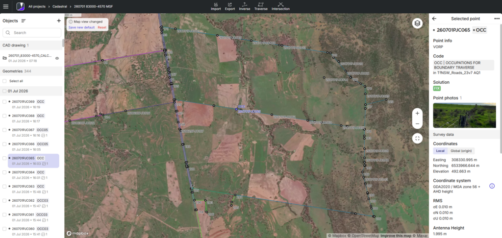
As Chris describes it, on a job where only two of the boundary marks in the field were found, the field surveyor can ask a colleague back in the office to download the pickup points, rework the boundary adjustment, and pushed the new calculation straight to the surveyor’s controller. No trip back to the office required.
On another job, three hours from the office, long grass had swallowed a culvert a surveyor needed to find. Chris recalls being in the office that day when a colleague, watching the surveyor’s real time position update on screen, talked him through finding it.
“From a supervision point of view, when the guys are taking a point out in the field, the surveyors back in the office can see that point turn up almost straight away on Flow 360 and be confident that field surveyors are on the right track“.
— Chris Nixon, Geospatial Technical Manager, Fyfe Pty Ltd
“Whether it’s a cadastral job where you’re trying to define boundaries—and the boundary fix might not always be perfect—if field surveyors take a shot with a photo, then the photo and metadata pops up straight away when office surveyors query the point. This helps the supervising surveyor to make sure that the technician in the field is on the right track.“, he adds.
Chris didn’t expect the workflow to matter this much when the team first switched. Safety was also a bonus; knowing exactly where team members are in real time.
Related reading: As-built surveys: a field-to-office workflow with Emlid Reach receivers
How the team of New South Wales shares projects, NTRIP profiles, and code libraries
The same folder structure scales the supervision model across the team. Every Fyfe surveyor working on Emlid receivers logs into a single Business account, with shared NTRIP profiles and shared code libraries across the team.
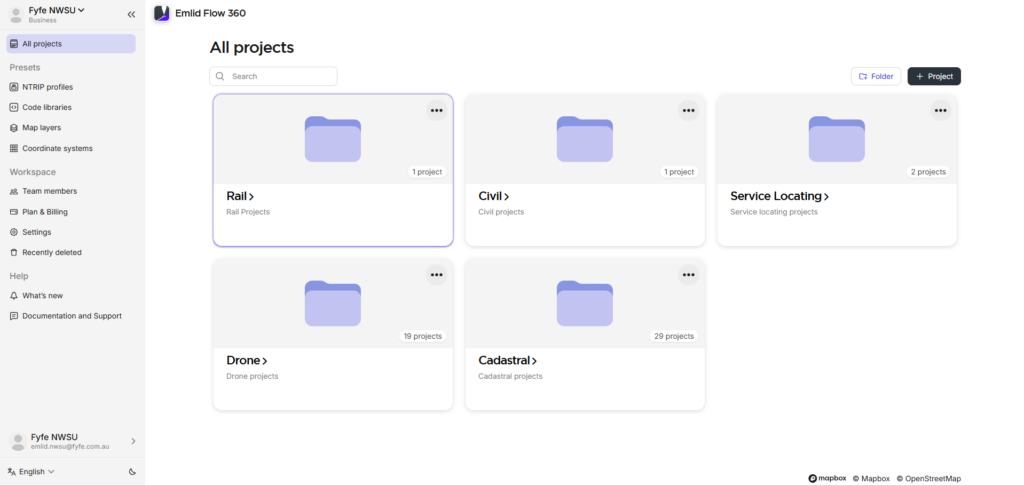
Before, spare units moved between crews on an ad hoc basis, with someone driving in from another site to drop off a receiver so a job could go ahead. With 10 units now in circulation across NSW, that back-and-forth has mostly disappeared, and a crew can pick up what it needs for the next day without interrupting anyone else’s schedule.
“The Emlid workflow is very well structured,” Chris says.
“The fact that anyone who’s linked as a team member can see all the projects within the folder structure, has access to all the NTRIP profiles, and be running off the same code libraries—it helps standardize what we’re doing. Essentially, it has everyone singing from the same hymn sheet for each job.”
— Chris Nixon, Geospatial Technical Manager, Fyfe Pty Ltd
Queensland, with about 30 Fyfe’s surveyors and locators, and South Australia, with about 60, are next in line for the same setup. Chris expects to fly up and walk both teams through how New South Wales built its workflow.
How Fyfe’s field crews came around to the Reach receivers
Chris is candid that the early resistance was cultural, not technical: a new-to-the-market unit made some surveyors wary before they’d even picked one up. Once they used it, they came around quickly.
Two details stood out to Chris:
- The receivers remember their configuration: a surveyor can set up a base station, power it down to charge overnight, and bring it back up the next day with logging, correction output, and connection settings intact.
- The rover’s SIM card lives in the receiver itself rather than in a separate controller, so there’s one less link in the chain when a crew needs a correction stream on site.
What the switch changed for Fyfe’s office and field crews
The savings extended past the hardware itself. Chris entices surveyors that use the Emlid rovers with new phones, which are cheaper than new controllers.This keeps everyone equipped with the latest technology without stretching the budget.
For Fyfe’s NSW team, the receivers were just the entry point. The bigger shift is an improved office workflow. From field to client deliverable more proficiently.
“The workflow is simple, efficient, and real-time, with everyone collaborating. Multiple people can work on the same project, with the metadata identifying individual surveyors working on the same project at the same time. Very impressive.”
— Chris Nixon, Geospatial Technical Manager | National, Fyfe Pty Ltd
Running construction crews across several sites? See how teams use Emlid receivers and Emlid Flow 360 to keep setout, checks, and as-builts in one shared workflow.